Sumatra quake in March reveals flaws in tsunami warning systems
Paul Somerville of Risk Frontiers examines the earthquake off Sumatra, Indonesia in early March, and looks at the breakup of the Australia – India Plate
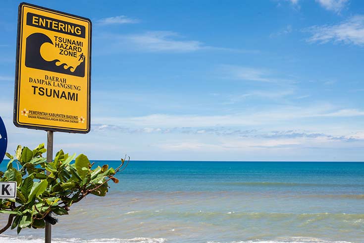
Tsunami warning sign on Batu Balong beach on February 19, 2012 in Bali, Indonesia (Paul Prescott /123rf)
On March 2, 2016, an Mw 7.8 earthquake occurred in oceanic lithosphere approximately 600 km to the southwest of the major subduction zone offshore Sumatra (Figure 1) at which the India and Australia plates subduct to the north-northeast beneath the Sunda plate. The oceanic lithosphere in which the earthquake occurred is commonly viewed as part of a broad zone of deformation (Figure 2) that separates the relatively undeformed interiors of the India and Australia plates and that accommodates the motion of the interior of the Australia plate north-northwestward with respect to the interior of the India plate at a velocity of roughly 11 mm/yr.
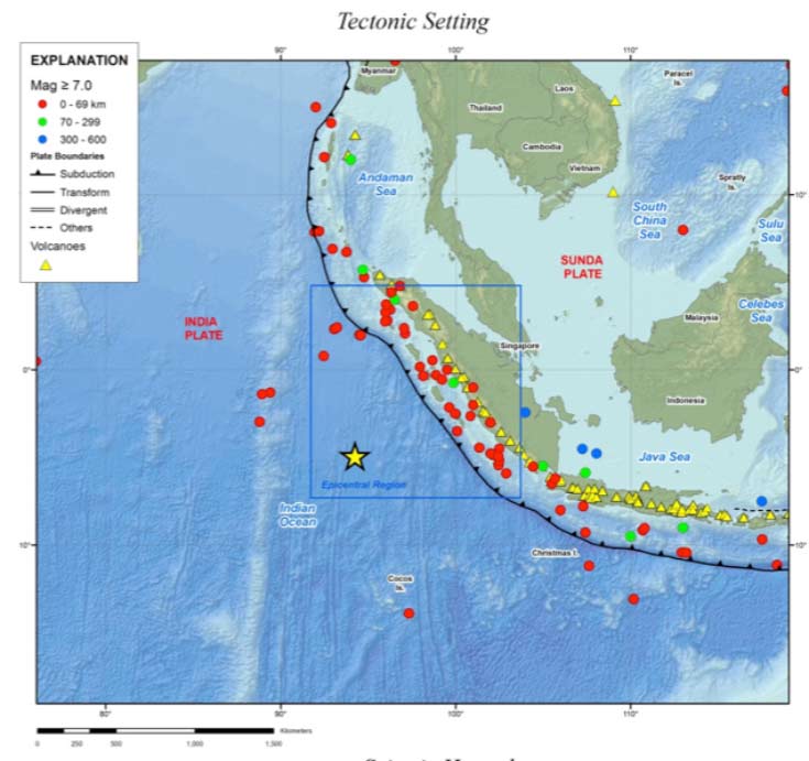
Figure 1: Location of the March 2, 2016 earthquake, shown by the yellow star. The 2004 Sumatra earthquake involved subduction of the Australia – India plate beneath Sumatra along the fault whose sea floor outcrop is shown by the black line running from top left to bottom right in the blue box (Source: USGS)
Large strike-slip earthquakes are not unprecedented in the diffuse plate boundary region separating the India and Australia plates, south-west of the Sumatra subduction zone. In 2012, two events of M 8.6 and M 8.2 on the same day (04/11/2012), whose locations are shown in Figure 2, ruptured a series of oceanic strike-slip faults 650-850 km to the north of the March 2, 2016 event. On June 18, 2000, an M 7.9 earthquake ruptured an oceanic strike-slip structure about 1,000 km southeast of the March 2, 2016 earthquake.
Because of the remote locations of these oceanic earthquakes, such events rarely cause shaking-related fatalities (though the 2012 M 8.6 event caused two). Also, strike-slip earthquakes do not typically generate tsunamis because they involve predominantly horizontal fault movement.
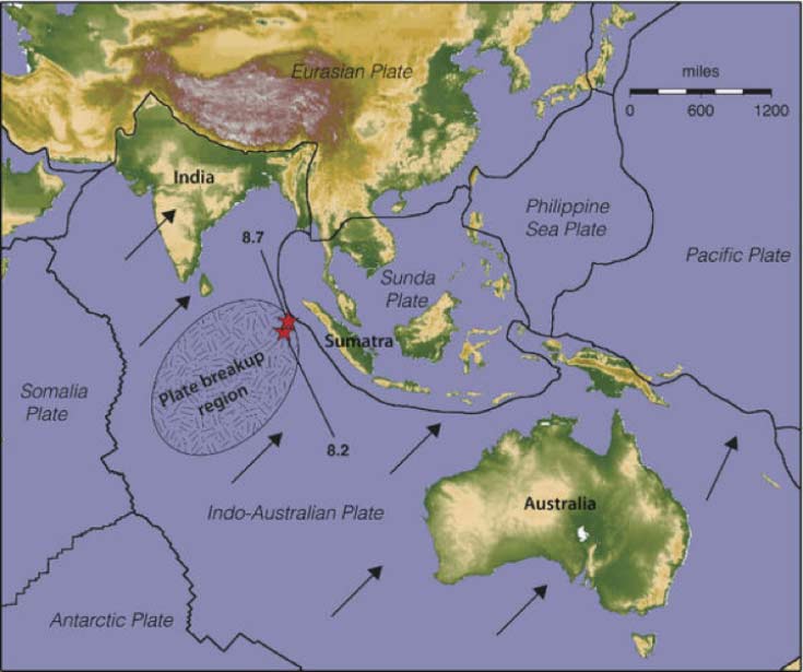
Figure 2: Boundaries and motion vectors of the Earth’s plates, epicenters (red stars) of two great earthquakes that occurred on April 11, 2012, and region of breakup of the Australia - India Plate (Source: Keith Koper, University of Utah Seismograph Stations)
The Mw 9.1 2004 Sumatra earthquake involved several tens of metres of movement of the Australia – India plate beneath Sumatra in the north-easterly direction shown by the arrows in Figure 2. This movement has clearly facilitated the occurrence of these subsequent large strike-slip earthquakes, which involve northeast extension of the interior of the plate in the direction of the arrows.
All 22 of the early-warning buoys Indonesia deployed after the 2004 tsunami disaster were inoperable when the earthquake occurred, mostly owing to vandalism. The earthquake on March 2 did not trigger a tsunami; there were no deaths and no major damage, but it did expose gaps in the systems put in place to prevent a disaster similar to that of the Mw 9.1 Sumatra earthquake that killed more than 200,000 people in 2004.
In addition to the malfunctioning of buoys designed to warn of massive waves, authorities said there were not enough evacuation routes or shelters in Padang, a Sumatra island port city of around one million people that felt the earthquake.
Soon after the 2004 disaster, Indonesia introduced a sophisticated early warning system using buoys, sea-level gauges and seismometers that can send alerts to countries' tsunami warning centers within ten minutes of an earthquake. The procedure is to issue a tsunami warning if an earthquake of more than 6.5 magnitude and with its hypocenter less than 20 km deep occurs at sea. That warning was issued immediately after the earthquake, but the buoys were the missing link in the chain.
Authorities delayed lifting their tsunami warning because of the inoperable buoys, which cost around $2.3 million a year to maintain. Government officials explained that they do not have enough money to afford this maintenance cost.
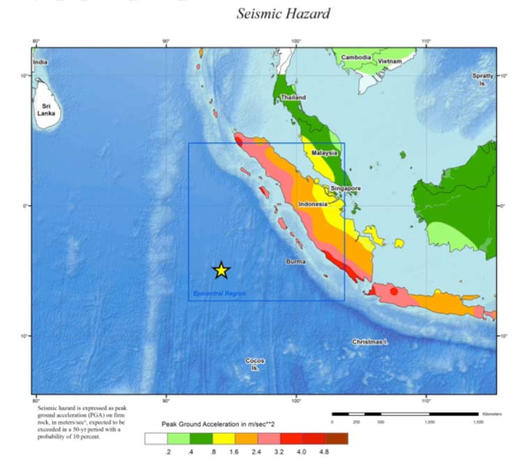
Figure 3: Seismic hazard map of Indonesia showing peak acceleration for 500 year ARP (Source: USGS)
Professor Paul Somerville is Chief Geoscientist at Risk Frontiers. He was born in Armidale, NSW and received his B.Sc. degree in Geophysics from the University of New England. He obtained his MSc and PhD in Geophysics at the University of British Columbia in Vancouver, Canada, and spent two years as a Visiting Research Fellow at the Earthquake Research Institute, University of Tokyo.
Dr Somerville has experienced numerous damaging earthquakes first hand, including the 1989 Loma Prieta, 1994 Northridge and 1995 Kobe earthquakes, and was involved in post-earthquake reconnaissance of these earthquakes, as well as other earthquakes in California, Japan, and Taiwan.
His main interests are in earthquake and tsunami hazards, and he has quantified these hazards and applied them in engineering practice to the seismic design and analysis of major buildings, bridges, dams and power generation facilities in Australia, New Zealand, Japan, the United States, and many other countries around the Pacific Rim.
Paul Somerville, 14/03/2016