People-centric technology targets disaster displacement
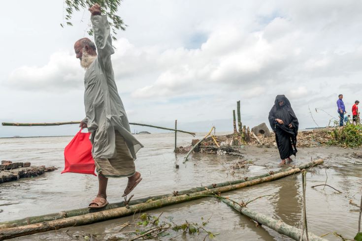
Heavy flooding caused by monsoon rains and the river's tide in Dohar, Bangladesh, 2016. Photo: Sohel Parvez Haque|123rf
As weather-related disasters force millions from their homes each year, new technologies are transforming the humanitarian response, writes Gareth Willmer.
When disaster strikes, the immediate death toll is first to hit the headlines. But a much longer-term problem is the potentially huge number of people forced to move – a figure set to surge amid the rising impact of climate change.
Over 17 million people worldwide were displaced by disasters last year, the vast majority of which were weather-related, according to a new report by the Internal Displacement Monitoring Centre (IDMC).
The number of people currently estimated to be living in internal displacement as a result of conflict and violence is also at its highest ever, at 41.3 million, the report states, adding: “Despite policy progress in several countries, the root causes of internal displacement are still not being adequately addressed.”
One of the biggest issues in the coming years, the report highlights, will be rising rural-urban migration, with 95 per cent of urban growth expected to happen in developing countries. Adding to rapid, unplanned sprawl, this threatens to make people even more vulnerable to climate change impacts, such as the now ‘staggeringly high’ risk of floods, the authors warn.
Poorer citizens will undoubtedly take the brunt of the hit. “Even a country that is relatively well prepared and disaster-aware is going to experience a disproportionate impact on its poorer population,” says IDMC director Alexandra Bilak.
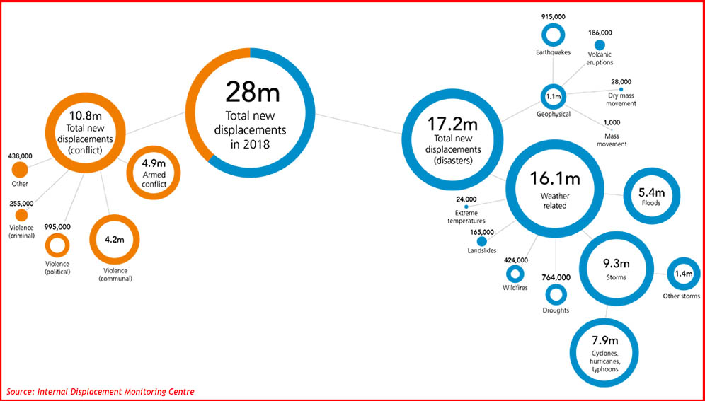
This image shows the breakdown of new displacements in 2018 for conflict, violence and disasters (IDMC).
Bangladesh tackles cyclones
As a low-lying, flood-prone nation, Bangladesh has sought to address this issue by developing early warning systems for cyclones.
Having long realised climate change was a problem, Saleemul Huq, director of the International Centre for Climate Change and Development (ICCCAD) in Dhaka stresses that: “We haven’t sat idle waiting.” He adds: “We’ve been trying to figure out what to do about it, and as a result have gone up a steep learning curve.”
That means cyclones now claim far fewer lives in Bangladesh, he says – pointing out that people knew what to do when Cyclone Fani hit in May, with over a million moving to shelters.
Disaster response has been boosted by the spread of tracking tech, smartphones, social media and new apps, aiding communication even among those who lack literacy skills, says Huq. But the longer-term effects of displacement from flooding remain a problem, he adds.
Even with systems in place, Dhaka – already among the world’s fastest-growing cities, with slums full to bursting – is unable to absorb the further 10 million people expected to be displaced in Bangladesh over the next two decades.
In what Huq describes as a “people-centred” pilot scheme, ICCCAD has pinpointed around 20 smaller towns deemed suitable for resettling up to a million migrants each in the future. Its aim is to get towns on board and allay economic fears.
“The carrot is that it will help their town grow,” says Huq. “We’re looking at how we make these towns climate-resilient but, more importantly, migrant-friendly to enable migrants to become citizens… We talk to the mayors and the people, and I wouldn’t say we’ve convinced them all, but they’re sufficiently interested to engage.”
Community mapping
The need to combine social and tech approaches for long-term solutions strikes a chord elsewhere, too. Innocent Maholi works on community-based mapping initiative Ramani Huria in Tanzania’s Dar es Salaam, a frequently flooded city where more than 70 per cent live in unplanned settlements and with a population expected to more than double by 2035.
The initiative, run by international organisation the Humanitarian OpenStreetMap Team (HOT), has been using drones and data from community mapping, including door-to-door surveys, to assess the position, types and material composition of buildings, roads, drainage systems and flood-prone areas, plus identify evacuation routes and safe refuges.
Engagement of citizens is key, says Maholi, adding that the ethos for the community is: “If we develop the map together, it should be our map, not Ramani Huria’s.” This has involved training local people on the tools, and enthusing them via initiatives such as “mapathons”, or mapping parties, as well as collaborating with universities to train hundreds of students.
A recent graduate who joined Ramani Huria has been developing a rapid-assembly drone made out of bamboo in a bid to create one at a cost of less than US$200. “I see a bright future in terms of us processing our own imagery so we can help people on the ground,” says Maholi.
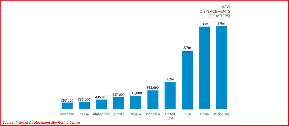
New displacements owing to disasters in 2018 (IDMC).
Satellite solutions
Meanwhile, smaller, cheaper and higher-resolution satellites are also improving displacement tracking. US firm Planet currently has about 140 satellites – including over 120 of its shoebox-sized Doves – collecting 1.2 million images daily, hitting sufficient fleet density by late 2017 to image the whole of Earth’s landmass each day.
Andrew Zolli, the company’s vice president of global impact initiatives, says the technology can help analyse where floods and landslides might happen, pre-position emergency services, and manage urban growth to avoid vulnerable areas.
Planet has also been working with the World Bank to develop AI tools to find every building in its imagery, enabling them to be viewed as they are being built. “This allows you to see the kind of progress of urban growth that is otherwise totally invisible, even to the urban managers who manage those cities,” Zolli explains.
In the Kutupalong camp in southern Bangladesh, populated by Rohingya refugees fleeing Myanmar, the imagery was harnessed to identify people to move from areas that became prone to landslides after trees were removed to build houses and cook food.
New displacements (disasters)
Planet is also working on satellite-linked financial instruments to help release funds the moment a disaster strikes. In addition, its imagery can also help people retain ownership of their land if they are temporarily displaced, even if a disaster has made an area unrecognisable. “Someone can say definitively that this is mine and this is where my family lives,” says Zolli.
Other breakthroughs are being made in artificial intelligence, which will eventually replace the often “resource-intensive and time-consuming” manual analysis of imagery, says Matthew Wencel, global GIS manager and settlement specialist at humanitarian association IMPACT Initiatives. He added that IMPACT partner UNOSAT (the Operational Satellite Programme of the UN Institute for Training and Research) has just produced its first AI-derived shelter analysis map for a resettlement camp in Syria.
AI technology in general, however, has not yet been effectively automated enough to save time, says Wencel, adding: “We continue to rely mainly on manual analysis, as the success rate of AI tools has historically been too low to offer any advantage over it.”
Freedom to innovate
Elsewhere, the UN’s Pulse Labs in Indonesia and Uganda are seeking to pioneer cutting-edge methods for harnessing big data for development by encouraging innovation through experimentation.
Pulse Lab Jakarta’s methods have led to the development of CycloMon, which tracks satellite data on the path of cyclones, and Haze Gazer, which wraps in user-generated data and has been adopted by Indonesia’s government to monitor wildfires.
“If something looks promising, the idea is to share it as widely as we can and map out how we go from here,” explains Derval Usher, head of office at Pulse Lab Jakarta, which she says is able to experiment in a ‘safe-to-fail’ environment.
The challenge, she emphasises, is working with governments to put the infrastructure in place, adding: “It’s very difficult to apply these methods in disaster contexts if you don’t have the agreements and regulatory frameworks in place.”
This need to cooperate closely on tech with governments is echoed by Einar Bjorgo, manager of UNOSAT, which runs the CommonSensing satellite project in Fiji, Vanuatu and the Solomon Islands aimed at improving climate resilience.
“I would say the technology is there,” says Bjorgo. “Now what we want to focus on is not necessarily new algorithms or tweaking to make it one per cent better, but to actually make use of it at the country level.”
The IDMC report points to some progress in this regard. In late 2018, for instance, Niger became Africa’s first country to incorporate the Kampala Convention – the world’s only legally binding regional instrument on internal displacement – into its domestic legislation.
Kerry-Lynn Maze, senior migration crisis analyst at the International Organisation for Migration, believes that momentum will grow with other African countries following suit. “I strongly hope that this is going to be the year of turning commitment into action,” says Maze. “Adopting the Kampala Convention alone won’t be sufficient, but I think having it creates an impetus to address these issues.”
More information can be found here
This content is licensed under a Creative Commons Attribution License
Image credit: route55|123rf