How night time lights seen from space could help disaster planning and response
Nasa scientists have released new global maps of Earth at night, providing the clearest yet composite view of the patterns of human settlement across the planet.
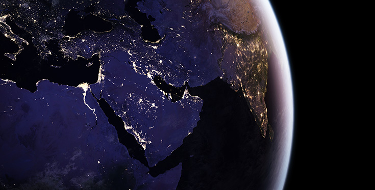
Composite image showing the River Nile and surrounding area at night (NASA Earth Observatory images by Joshua Stevens, using Suomi NPP VIIRS data from Miguel Román, NASA's Goddard Space Flight Center)
Since colleagues from the National Oceanic and Atmospheric Administration and NASA released a new Earth at night map in 2012, Román Earth scientist Miguel Román of NASA’s Goddard Space Flight Center in Greenbelt, Maryland and teammates at NASA's Earth Observing Satellite Data and Information System (Eosdis) have been working to integrate night-time data into NASA's Global Imagery Browse Services (GIBS) and Worldview mapping tools.
The satellite's workhorse instrument is the Visible Infrared Imaging Radiometer Suite (VIIRS), which detects photons of light reflected from Earth's surface and atmosphere in 22 different wavelengths. VIIRS is the first satellite instrument to make quantitative measurements of light emissions and reflections, which allows researchers to distinguish the intensity, types and the sources of night-lights over several years.
"Thanks to VIIRS, we can now monitor short-term changes caused by disturbances in power delivery, such as conflict, storms, earthquakes and brownouts," said Román. "We can monitor cyclical changes driven by reoccurring human activities such as holiday lighting and seasonal migrations. We can also monitor gradual changes driven by urbanisation, out-migration, economic changes, and electrification. The fact that we can track all these different aspects at the heart of what defines a city is simply mind-boggling."
For instance, VIIRS detected power outages in the wake of Hurricane Matthew, a major storm that struck the north-eastern Caribbean and the south-eastern United States in late September 2016. Nasa’s Disasters Response team provided the data to colleagues at the Federal Emergency Management Agency (FEMA); in the future, Nasa, FEMA and the US Department of Energy hope to develop power outage maps and integrate the information into recovery efforts by first responders.
The NASA team envisions many other potential uses by research, meteorological and civic groups. For instance, daily night time imagery could be used to help monitor unregulated or unreported fishing. It could also contribute to efforts to track sea ice movements and concentrations. Researchers in Puerto Rico intend to use the dataset to reduce light pollution and help protect tropical forests and coastal areas that support fragile ecosystems. And a team at the United Nations has already used night-lights data to monitor the effects of war on electric power and the movement of displaced populations in war-torn Syria.
In a separate, long-term project, Román is working with colleagues from around the world to improve global and regional estimates of carbon dioxide emissions. The team at Nasa’s Global Modeling and Assimilation Office (GMAO) is combining night lights, urban land use data, and statistical and model projections of anthropogenic emissions in ways that should make estimates of sources much more precise.
Freely available to the science community and the public via the Web, GIBS and Worldview allow users to see natural- and false-colour images of Earth within hours of satellite acquisition.
https://youtu.be/8dc58ZrOuck